


 The volcanic eruption started at Sundhnúks crater row at 21:26 UTC 22 August. This photo is taken one hour after the eruption started and the eruption fracture is estimated approximately 4 km long. Photo: Björn Oddsson/Civil Protection.
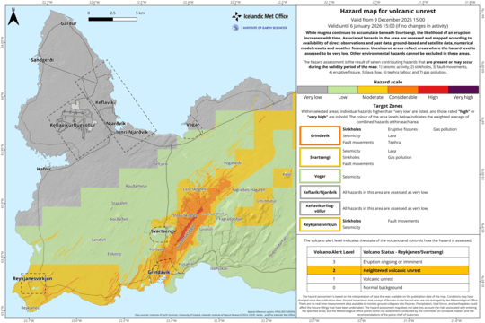
Zones 3, 5, and 6 Expanded to the Northeast
Updated 3. September at 17:30 UTC
The Icelandic Meteorological Office has updated its hazard assessment to reflect developments in the eruption, and this update remains valid until September 5, unless significant changes occur. The main update to the current assessment is that zone 5 has moved from high risk (red) to considerable risk (orange). This downgrade is due to a reduced risk of ashfall. The risk of gas pollution has been assessed considering the weather forecast for each zone over the coming days.
Another update to the hazard assessment map is that zones 3, 5, and 6 have been expanded by 2 km to the northeast. This change was made for two reasons. First, the new lava field created in this eruption has extended beyond the previous boundaries of these zones. Second, the magma dike formed on August 22 extended further northeast than zone 3 previously covered.

Updated 3. September at 14:00 UTC
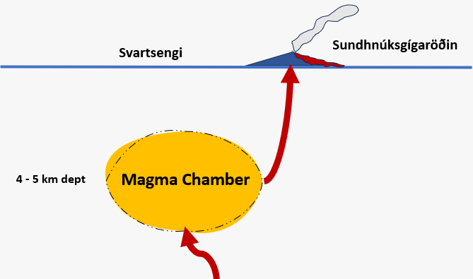
The influx of magma into the reservoir beneath Svartsengi is likely equal to the outflow from the eruption.
Two active eruptive vents are located along the northern part of the fissure.
Seismic activity has decreased in recent days.
The hazard assessment will be updated later today.
In the past few days, no land uplift or subsidence has been detected at Svartsengi. This suggests that the inflow of magma into the reservoir beneath Svartsengi is comparable to the outflow of the eruption.
Several days of measurements will be necessary to confirm that land uplift has resumed. This is because day-to-day changes in geodetic measurements can occur due to various factors, including variations in atmospheric humidity or solar storms.

Two eruptive vents are currently active in the eruption that began on August 22. The intensity of the eruption has significantly decreased in recent days. The lava field north of the vents continues to expand, but its rate growth has considerably slowed. For now, the lava flow does not threaten infrastructure near the eruption sites. The accompanying map, based on Iceye satellite data, shows the development of the lava field from August 26 to September 1.
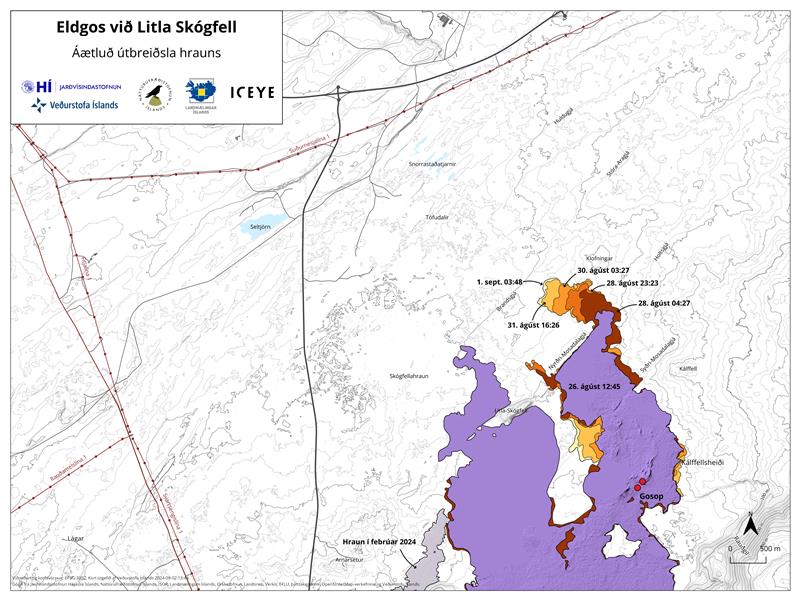 A map showing the actively expanding part of the lava field that formed during this eruption. The map is based on data from the Iceye satellite.
Seismic activity around the Sundhnúkur crater row has significantly decreased in recent days. Most of the minor earthquakes that are being recorded are located on the northern part of the fissure that was active at the beginning of this eruption.

www.malaymail.com/news/world/2026/01/11/bomb-attac…
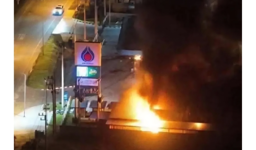
BANGKOK, Jan 11 — A series of late-night bomb attacks targeted 11 PTT petrol stations in Thailand’s southern border provinces of Narathiwat, Pattani and Yala…
www.khaama.com/at-least-eight-refugees-die-37-resc…

At least eight refugees died and 37 were rescued when their boat sank off Badmeli near Izmir, Turkish authorities said on Saturday.
katu.com/news/local/oregon-confirms-first-measles-…

Health officials in Oregon have confirmed the state's first measles cases of 2026, with two people diagnosed in Linn County.
abc11.com/post/measles-north-carolina-state-report…
Measles in North Carolina: State reports 5th case linked to South Carolina surge