Iceland Volcano: Uplift Has Resumed; Considerable Pollution Measured -- Iceland Met Office
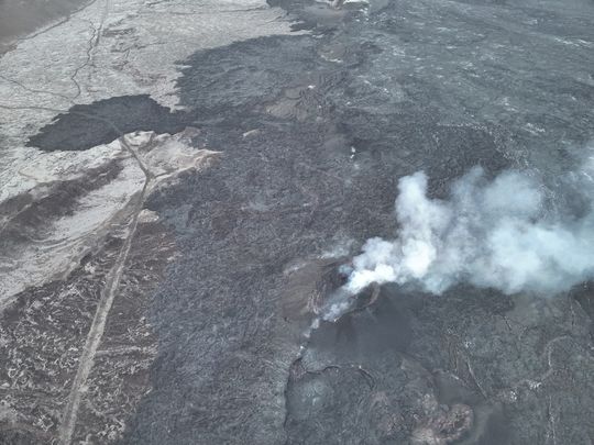 From the Civil Defense patrol flight on May 9. No lava splashes are visible in the crater, although smoke continues to pour out of it. (Photo: Civil Defense)
Considerable pollution measured from the eruption
Measurements indicate that uplift has resumed
Updated 11. June at 16:00 UTC
- The eruption has lasted for 13 days. One crater active which remains relatively stable
- Considerable pollution from the eruption in many parts of the capital area and in the western part of South Iceland
- It is not recommended to engage in outdoor activities in the areas where pollution is detected. Air quality can be monitored here
- Measurements indicate that land uplift has resumed
- Lava still collects in a lava pond just southeast of Sýlingarfell
The eruption at the Sundhnúkur crater row that started 13 days ago remains stable. One crater is active, and the activity has been similar in the last few days. Seismicity has been very low in the last week, only a few earthquakes have been detected.
As reported in our news over the weekend, the flow of lava began to increase at the roots of Sýlingarfell to the west, and Grindavík road was inundated by lava for the third time since the volcanic activity began at Sundhnúkur last November. The lava tongue still progresses and is now flowing to the northwest along a similar channel as the one that flowed over Grindavík road on Saturday. However, its active flow front is still a few hundred meters away from the road and moves very slowly. Lava is still accumulating in a lava pond just southeast of Sýlingarfell and could burst again and trigger another surge of lava in the next few days.
Measurements suggest that land uplift started again last weekend and the subsidence that was detected in the first days of the eruption has stopped. The rate of uplift cannot be estimated yet, but it can be assumed that the inflow of magma into the magma reservoir has exceeded the outflow from the crater.
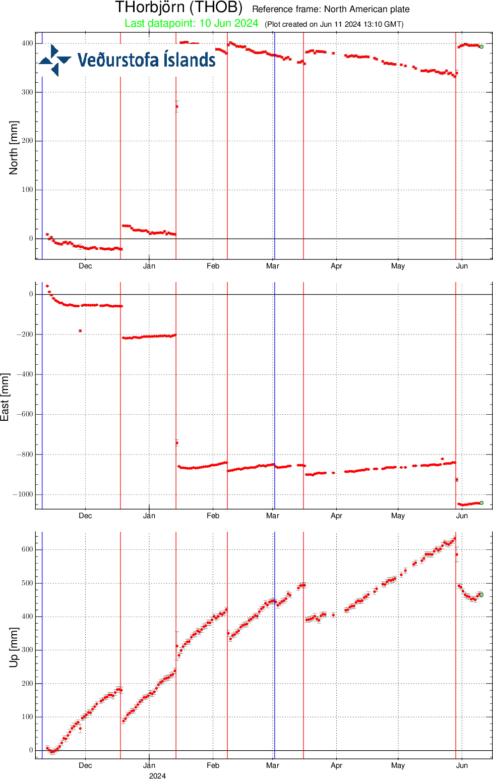 Caption: Movements at the GPS station THOB on Þorbjörn since 11 November 2023 in north, east and vertical (top, middle, bottom). The lowest graph shows land uplift in millimeters, and yesterday's (10 June) measurement is shown with a green dot. The red lines are the dates of the beginning of the last five eruptions (18 December 2023, 14 January, 8 February, 16 March and 29 May 2024). The blue lines represent the timing of the magma propagations that have occurred without resulting in an eruption (10 November 2023 and 2 March 2024).
Pollution could have health effects
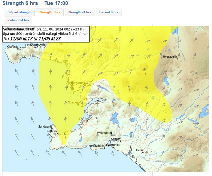
Considerable pollution from the eruption is now measured in many parts of the capital area and in the western part of South Iceland. According to data from the Environment Agency of Iceland, the highest levels of SO2 in the capital area have exceeded 500 μg/m3 and the pollution is expected to persist throughout the day. People with sensitive respiratory systems may experience discomfort. It is preferable to limit physical activity outdoors and avoid letting infants sleep outdoors during such high concentrations of gas in the air.
This morning, fog clouds have settled over the western part of the country, and there has also been visible volcanic smog caused by the conversion of SO2 gas into SO4. Volcanic smog is composed of very fine sulphur particles (SO4) that have been formed as a result of the chemical reaction of the volcanic plume with moisture and oxygen in the atmosphere with the aid of sunlight. When the day is long, as it is now, there is an increased chance that volcanic smog will form. Volcanic smog is not measured on SO2 gas detectors, but is visible as a blue mist when a certain concentration is reached. An increase in very fine particles (PM1 and PM2.5) may be an indication of the presence of SO4. Air quality can be monitored on the Environment Agency's air quality detectors.
The weather watch's forecast of gas distribution is rather slow, variable direction and gas pollution can be seen in many parts of the southwest corner. Turning southerly in the afternoon, gas blowing to the north and pollution could be felt in Vogar and Reykjanesbær. Southeasterly winds tomorrow, gas blowing to the northwest.
- CategoriesEdited | All Content | Disasters | Earthquakes | Volcanos | Government | Health | Science | Europe | Atlantic Ocean | News -- WNT Selected
- Date rangeTuesday, June 11, 2024
- Last modifiedTuesday, June 18, 2024
